Dooloo Creek, Queensland
Project
Location & Access
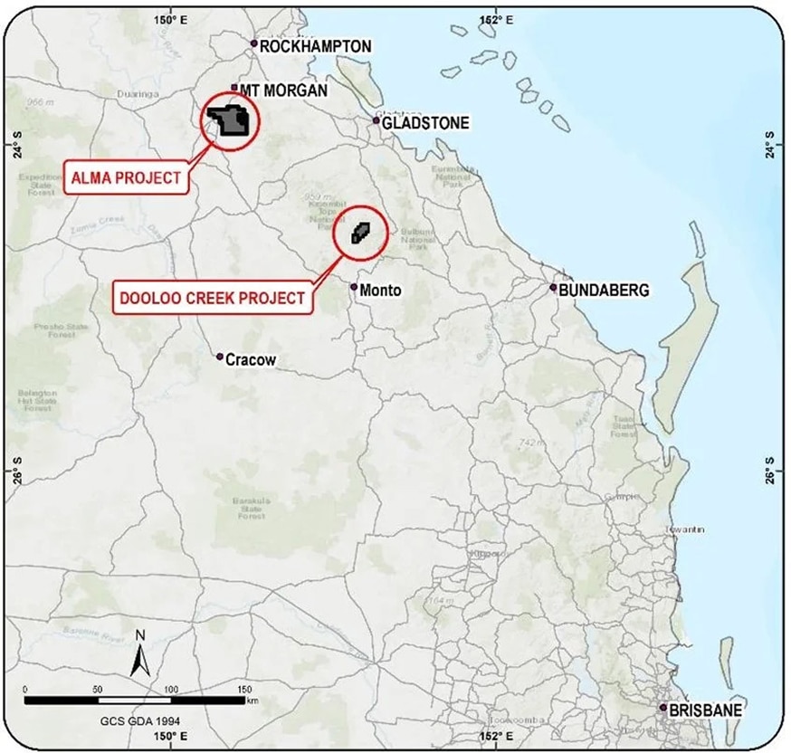
The Dooloo Creek project (EPM 15343 & EPM 27728) is located 500km northwest by road from Brisbane and approximately 50km north of the township of Monto in southeast Queensland, Australia and is prospective for gold and copper mineralisation. With a population of approximately 1,200 people, Monto is the nearest population centre.
The economy of the region is largely agricultural, and the topography is rugged, however the property is well accessed through secondary roads and tracks via an established track running north to Dooloo Tops from the township of Mungungo. There are several gazetted tracks plus farm and logging tracks within the area providing pre-established routes through the project area.
History
Discovered in 1966, the Dooloo Creek project, EPM 15343 (contiguous with EPM 27728), is prospective for gold and copper. The prospect and the surrounding area was subject to an intensive program of geological mapping, preliminary drilling and geochemical sampling as well as ground and aerial geophysics. At the time nine RC holes were drilled, totaling 1,303m. The holders, North Limited, were unable to continue with the project due to extensive layoffs and budget cuts. This resulted in the anomalism which was defined in the very late stages of the exploration project by the Company, remaining largely untested.
Horton Geoscience Consultants Pty Ltd and Energy Minerals Pty Ltd were granted an exploration license over the prospect in 2000 and the main area of the anomalism and a further 10 RC holes totaling 1,623m were drilled. However, 5 years of litigation between the two companies resulted in the drill holes not being assayed and the tenement was surrendered in 2005.
Diatreme Resources Ltd acquired an exploration license over the project area in 2007, subject to an agreement with Horton Geoscience Consultants. Diatreme drilled nine RC holes, totaling 1,369m, and two diamond core holes, totaling 809m, over the next three years. They also reinterpreted previous geophysical data over the project. Assay results from these drilling programs revealed the near surface mineralisation representing the upper halo of a gold-copper ore body. Over 60% of the 552 assays from drilling contained detectable gold with the best interval being 12m @ 1.38g/t Au from 125m in drill hole DCRC04. Individual copper assays recorded up to 0.14% Cu over 2m. In October 2010 Diatreme assigned the tenement to Horton Geoscience Consultants. Devonian Gold, GGR’s subsidiary, now owns 100% of Dooloo Creek and the company has the benefit of over 20 years of annual reports on the project to help inform the current round of exploration.
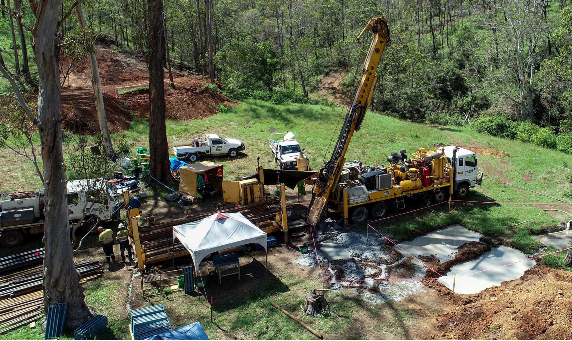
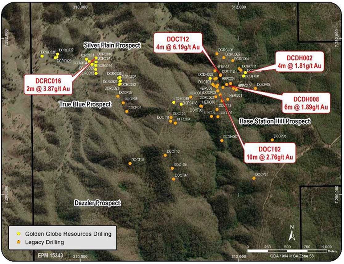
GGR have completed significant exploration activities at Dooloo Creek including the drilling of 24 RC holes for 2,178m and 3 diamond core holes for 1,840m. The results of this drilling and from almost 800 individual soil and rock-chip geochemical samples have confirmed the presence of multiple, substantial areas of interest. Results from GGR drilling include 2m @ 3.87g/t Au from Silver Plane and 4m @ 1.81g/t Au at Eastern Breccia. In early 2023 GGR engaged the services of industry experts Global Ore Discovery, a Brisbane based Geoscience consultancy and Corporate Development group. All data for Dooloo Creek was re-interpreted by Global Ore and a geological model developed to aid target generation. This is the basis of GGR’s ongoing exploration program and will continue to be developed and tested.
Key Aspects
- Prospective for large-scale gold-copper.
- Mineralisation in the area considered to be comparable to a Mount Leyshon style gold-copper system.
- Approximately 75% of all geochemical samples collected in past exploration within the prospect areas contain detectable gold.
- The lease is located 50km north of Monto in southeast
- Freehold land tenure resulting in no Native Title claims over the Dooloo Creek Project was found to be anomalous in gold extending along strike to the yet to be assessed Dazzler prospect in the southwest area of the tenement.
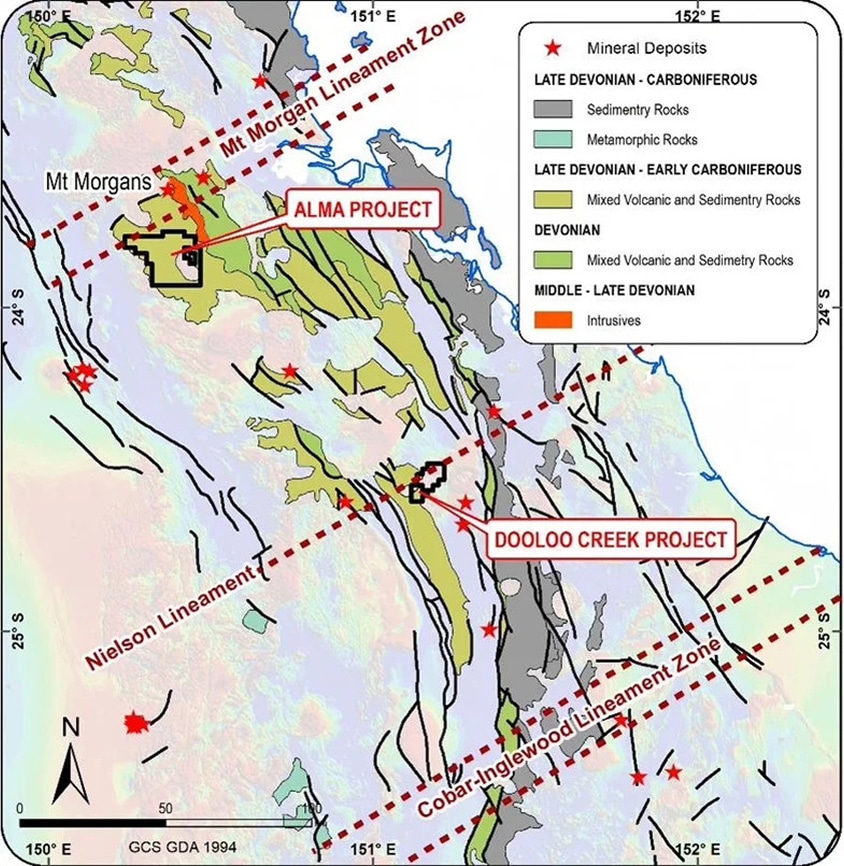
Regional Geology and Mineralisation
The Dooloo Creek gold-copper project lies in Devonian volcaniclastics dated from corals in limestone clasts as Frasnian in age (Early Upper Devonian). The project lies adjacent to a large andesitic body to the southwest which is interpreted to be both a volcanic plug and the centre of a Devonian volcanic/volcaniclastic complex which grades to sedimentary facies laterally away from its centre. The smaller Dazzler and Algonquin gold-in-rock anomalies associated with the plug and volcaniclastics to the west respectively, are of minor significance compared to the Dooloo Creek project. The volcanic/volcaniclastic assemblage has been mapped as part of the sedimentary Devonian to Early Carboniferous Three Moon Conglomerate. Triassic granites to the northwest placed along the Nielsen Lineament intrude the volcanic/volcaniclastic complex. The complex is overlain by the Triassic Dooloo Tops Volcanics (rhyolite) to the east. Minor rhyolite dykes intrude the volcaniclastics. The Dooloo Creek project lies partly within the contact aureole of the Triassic granites and skarns and hornfels are common.
Local Geology and Mineralisation
Gold mineralisation is widespread within the region. The main area of historical mining was the Monal Goldfield located to the north of the tenement. Here pyrite/chalcopyrite bearing quartz reefs were mined by way of deep shafts and adits. The area has produced approximately 606kg Au from approximately 22,000 tonnes of ore with the principal producers being the Lady Griffith and United Rise Mines.
Within the local area of interest, the geology can be assigned to five main units:
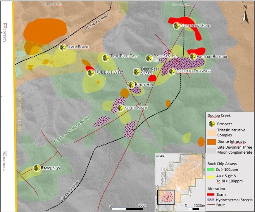
- Late Devonian andesitic volcanics, volcaniclastics, and sediments: These rocks form one of the major units within the area and consist of lithic arenite, siltstone, coarse volcaniclastics and basaltic andesitic lava and Originally, they were mapped as Dawes Range Formation by Dear & others (1971), however they have been incorporated within the Devonian to Carboniferous Three Moon Conglomerate in the latest mapping (Queensland Geological Survey). More correctly, based on recent mapping by the University of Queensland (Bryan & others, 2001), they form part of the mid to Late Devonian Lochenbar Beds. While the extent of these rocks has not been defined, they are present south of the Glassford complex within the Dooloo Creek and Monal Creek catchments.
- Devonian-Carboniferous Sediments: These sediments consist of lithic+feldspathic arenite, conglomerate, oolitic and crinoidal limestone, dacitic tuff, andesitic lavas and tuff mudstone, siltstone, shale and conglomerate. They originally included the Crana Beds and Cania Formation of Dear & others (1971) but are now mapped as Three Moon Conglomerate and Rockhampton Group.
- Triassic Glassford Complex: comprised of mainly granodiorite, adamellite and tonalite.
- Triassic Dooloo Top Volcanics: (formerly Muncon Volcanics) consisting of intermediate and mafic lavas and subordinate siltstones and Recent mapping shows that in the tenement area they are likely underlain by an intense north-northwest trending rhyolite dyke swarm up to 1km wide.
- Tertiary Basalt: consisting of olivine bearing basalt often with a basal conglomerate occupying paleochannels. At least one basalt plug is known in the Alluvial gold workings occur in the Spring Creek area to the west of the tenement. Although some small hard rock gold occurrences are recorded here, no source for this alluvial gold is known. Gold mineralisation has also been mined historically in the Dooloo Creek area (Dooloo Diggings) where gossanous quartz reefs and copper bearing skarns were mined by way of shallow pits. Alluvial gold was also discovered from this area.
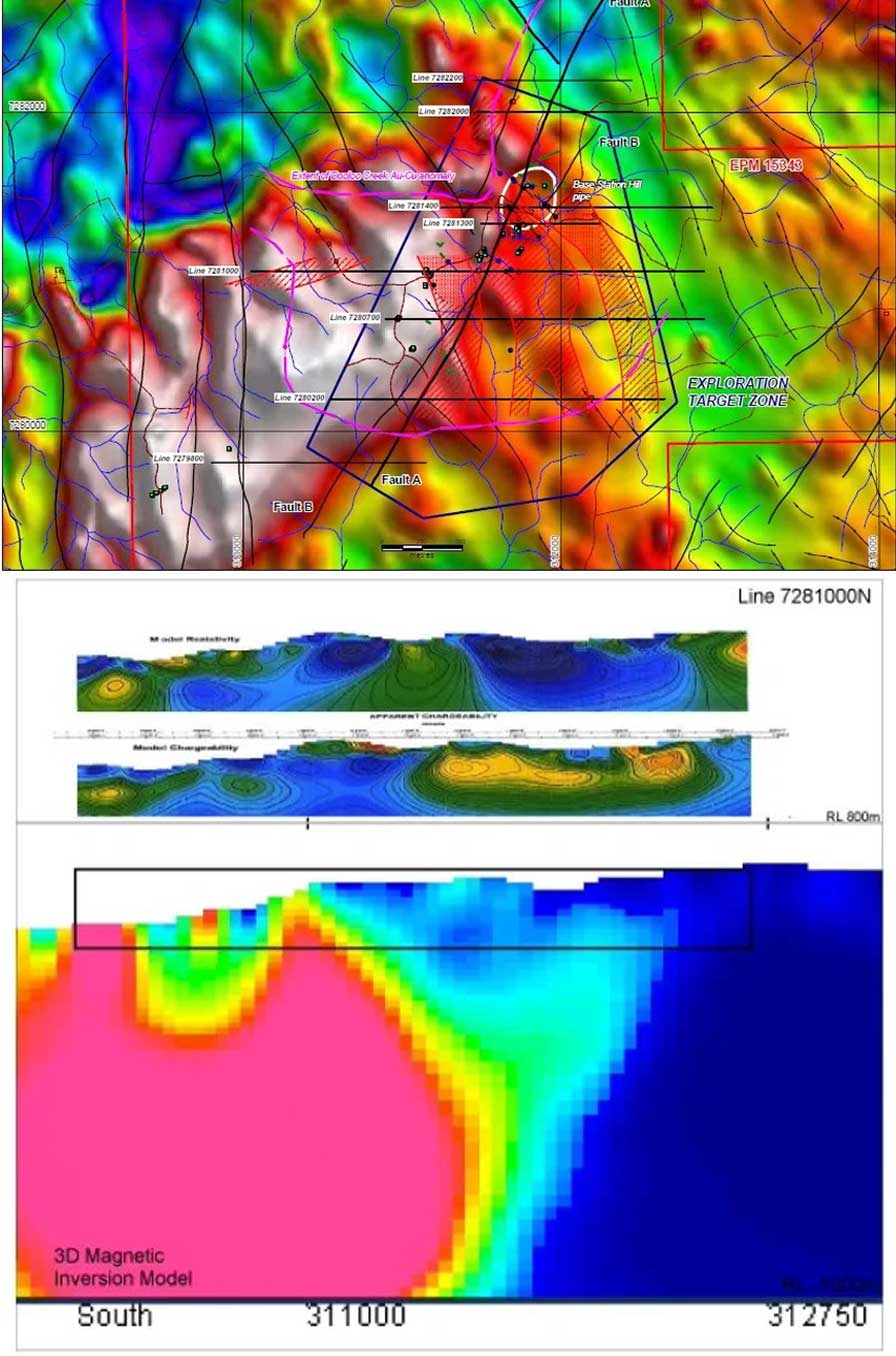
Conceptual Target
The shallow level IP and 3D magnetic model below indicates the relative depth extent of the models for both IP and magnetics for Line 7281000 across the Dooloo Creek prospect: (the magnetic model section has a much greater depth extent than the IP model section, and the equivalent IP model area is outlined on the mag model).
Of the eight lines of IP conducted at the Dooloo Creek prospect, five have 2D smooth-model inversion sections presented in reports. The relevant Resistivity and Chargeability model sections for these five lines were extracted and registered in the MapInfo GIS database.
When plotted against the maximum Au intercepts in the available drill holes, a pattern emerges which indicates that the Au mineralisation is concentrated on the periphery of the interpreted andesite centre. This peripheral zone appears to be slightly magnetic in the magnetic inversion models, but not as strongly magnetic as the interpreted andesite centre at depth.
The inference from these observations is that potential for further Au mineralisation exists along the outer contact of the andesite centre, and this can possibly be targeted with further deep IP guided by the 3D magnetic inversion model.
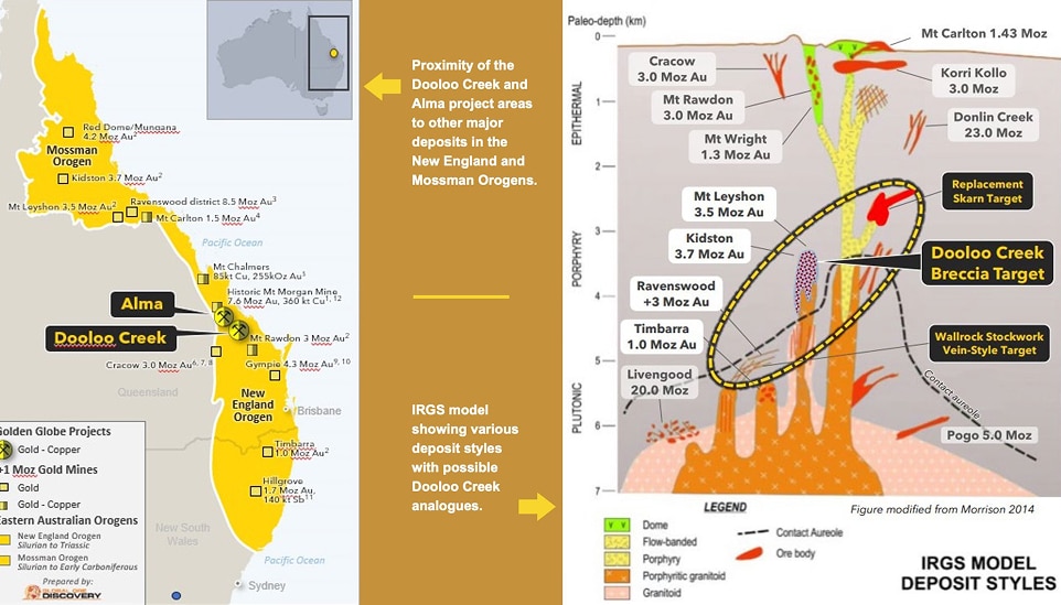
Exploration Model – Target Generation
The primary exploration target in the tenement is considered to be analogous with the mineralisation style seen at the Mount Leyshon gold-copper deposit. Recent work completed by the Company and based on results from Global Ore Discovery modeling, has investigated various geological models that will assist with the formation of exploration targeting for future drilling. The schematic figure below demonstrates that the project areas of both Dooloo Creek (and Alma) are situated in highly prospective current and historic mining provinces. The Company has drawn comparisons to multiple styles of gold – copper systems and confidently uses these analogies in developing our own exploration model.
Drill Ready Targets
GGR had completed a substantial program of field work in 2020 aimed primarily at investigating and sampling previous high grade gold occurrences. This work successfully confirmed the presence of high-grade gold as well as wide-spread anomalism in gold, copper and associated trace elements. The occurrences of alteration and mineralisation styles typically associated with mineral deposits were also confirmed. The alteration/mineralisation is widespread suggesting the possibility of multiple orebodies. Following the 2020 field work program, the Company undertook the aforementioned drilling programs completing 24 RC holes for 2,178m and 3 diamond core holes for 1,840m. Results from this work proved indicative of widespread Au and Cu mineralisation across several areas of interest and are summarised in the figure below.
Considerable work accomplished at Dooloo Creek to date:
- Rock Samples: 195
- Soil Samples: 560
- Detailed Magnetics
- Induced Polarization
- Drilling:
- 2,178m of Reverse Circulation (24 holes)
- 1,840m of Diamond Core (3 holes)
- Downhole electromagnetics
Best GGR drill results at Dooloo Creek:
- 2m at 2.87g/5 Au (Silver Pain)
- 4m at 1.81g/t Au (Eastern Breccia)
- Anomalous gold and copper in all 27 holes
- Mount Cannindah project 20km SW hit 1m at 96g/t gold
Combined with the remodeling of all historic data and including this most recent drilling and surface geochemical sampling, several specific ‘areas of interest’ have been defined. These are considered to be drill-ready targets and will be tested in the next phase of drilling, outlined in the table below.
Drill Ready Targets
GGR had completed a substantial program of field work in 2020 aimed primarily at investigating and sampling previous high grade gold occurrences. This work successfully confirmed the presence of high-grade gold as well as wide-spread anomalism in gold, copper and associated trace elements. The occurrences of alteration and mineralisation styles typically associated with mineral deposits were also confirmed. The alteration/mineralisation is widespread suggesting the possibility of multiple orebodies. Following the 2020 field work program, the Company undertook the aforementioned drilling programs completing 24 RC holes for 2,178m and 3 diamond core holes for 1,840m. Results from this work proved indicative of widespread Au and Cu mineralisation across several areas of interest and are summarised in the figure below.
Program: 2,000m diamond core in 4 x 500m holes plus 2,000m of RC drilling in 8 x 250m holes. Number of holes and depth could vary depending on geology and analytical results. See figure below for hole locations.
| Target | Prospect | Target Justification | Current Drill Program |
|---|---|---|---|
| 1 | Northern Gold | No previous drilling. Outcropping skam +/- anomalous copper and tungsten. Rock chip samples assaying up to 29g/t Au and 0.15% Cu. Overlapping geophysical features. Current 3D model identifies area as high priority target. | One diamond drill hole to approximately 500m. |
| 2 | North side of Base Station Hill | No previous drilling. Outcropping mineralised breccia hosted in favourable lithology. Overlapping structural and geophysical features. Current 3D model identifies area as strong target. | One diamond drill hole to approximately 500m. |
| 3 | Eastern Breccia | Previously partially tested by GGR drill hole; intersected strong hydrothermal alteration and brecciation at 18-120mm depth; best results 3m @ 2.3g/t Au and 7m @ 0.17% Cu (incl. 1m @ 0.45% Cu). Clearly mineralised part of system. | Two diamond drill holes, each to approximately 500m. |
| 4 | True Blue West | Previous shallow RC drilling (maximum 80m vertical deph) of a coincident gold-copper soil anomaly intersected weakly altered intrusive and skam mineralisation - may represent a halo to better mineralisation at depth. Ranks well as a target in overall exploration model. | Up to eight RC drill holes, each of approximately 250m for a total 2,000m to test previously identified shallow anomalism. |